A number of articles on our resource have already examined in detail the main confrontations in the field of navigation applications. In particular, we have already compared Yandex and Google Navigators, as well as programs from Navitel. Most readers of the site liked the material, and therefore many of them suggested separate topics for review.
Most often, motorists asked to compare Maps and Navigator from Yandex. We decided to go even deeper and conducted detailed comparison not only these programs, but also their main analogues. What came out of this, see below.
Maps or Navigator
Let's start today's article with a basic comparison and try to answer the question that interests many - “Which is better: Yandex Maps or Yandex Navigator?” First of all, let’s define what these programs actually are. Let's start with the Maps.

So, Yandex Maps is a navigation and information program from the brand of the same name. It is published in Russian for absolutely any operating system among those used on smartphones or other digital devices. At its core, it is a program that allows view maps of more than 350 cities and small towns in real time, which are located on the territory of the post-Soviet space. The main functions of this application are:
- previously mentioned - viewing maps, as well as downloading them to the device for permanent access;
- possibility of building optimal route both for personal transport and public transport;
- search for data on the most interesting places on the map;
- provision of the People's Map (diagrams, photographs and other information about settlements, which is posted by users).
In general, Maps is a mixture of a regular map manager and a typical navigator. Such an organization of the program is most convenient not for motorists, but for travelers to unfamiliar places. You will find out why things are this way after a more detailed review of the Yandex Navigator application.

Yandex Navigator is a highly specialized application, which is a program based on Yandex Maps. That is, this program, as its name suggests, is aimed at convenient use as a navigation assistant. This can be most clearly seen in the main functions, or more precisely:
- the ability to build the most optimal route for both personal transport and public transport;
- indication of information about the presence of accidents and traffic jams;
- voice accompaniment movement along a given route;
- Availability different modes map display (3D, 2D, etc.);
- more fine tuning navigation options.
At the same time, in Navigator you cannot find out about interesting places along the route and use similar functions, presented in Maps. This organization of work is no longer more convenient for travelers to unfamiliar places, but specifically for motorists.
Important! It turns out that for high-quality and convenient navigation it is better to use Navigator, and when traveling to unfamiliar places for the purpose of travel - Maps.
2GIS or programs from Yandex
Now that the answer to the main question of today’s article has been given, it would be useful to pay attention to a comparison of applications from Yandex with their analogues, perhaps competitors. Naturally, previously discussed confrontations will not be listed. First of all, let's compare the application of the well-known help service- 2GIS, with Maps and Navigator.

Let us note right away that in the question “Which is better: 2GIS or Yandex navigator?”, the answer is extremely simple: of course, the latter. We will not consider this comparison in detail, because 2GIS does not have a special navigation focus, therefore use to obtain high-quality navigation Yandex is better Navigator, which was created precisely for this purpose. But comparing 2GIS and Maps is quite interesting.
First of all, let us agree that this moment 2 GIS is mapping service with an informational bias. This means that in this application it is more convenient to search for information about various objects rather than receive full-fledged maps. In particular, 2GIS has one of the best details in the cities where it operates, even down to displaying small municipalities and detailed information about them (opening hours, reviews, etc.). However, in other parameters, 2GIS is clearly inferior to Yandex Maps, because it has:
- less accurate and complete system terrain display;
- there is only the ability to view the map, that is, 3D and 2D modes are not available;
- little information about the situation on the roads (traffic jams, accidents, etc.);
- No voice functions;
- Overall little functionality.
Summarizing the comparison, it is worth stating: 2GIS is the application that is more convenient to use to obtain information about the organizations of the city or its map when present in the very locality. It is much better to create a route and carry out similar operations related to cartographic planning in Yandex Maps.
CityGuide or programs from Yandex
At the end of today's material, we will also consider quite interest Ask, namely, “Is CityGuide or Yandex Navigator more convenient to use?” Let us immediately note that to compare this application with Maps is quite irrational, because its focus is completely similar to Yandex Navigator and consists in organizing convenient navigation for the user.

In general, there is no special comparative debate between the two applications. Both are made quite well, but relative to Yandex Navigator CityGuide has both its advantages and disadvantages. Let's look at each of them. So, the advantages of CityGuide:
- faster response to traffic situations;
- clearer, more timely and convenient construction of the current route;
- Slightly better organized navigation features.
The disadvantages of the programs are the following:
- need to purchase paid version to get all the functionality of the application;
- terrible design (primitive, ugly, etc.);
- in terms of the information component it is also inferior.
For the rest, both CityGuide and Yandex Navigator - similar programs, you should choose from them based on your needs and taking into account the features presented above.
This, perhaps, is where today’s material comes to an end. We hope the article was useful to you and provided answers to your questions. Good luck on the roads!
Video review of the best navigation programs of our time:
To always easily find the right road in any city and anywhere, most people use GPS navigators, however, technology does not stand still: now you can have a convenient and fast navigator right in your smartphone. Yandex service provides its users free application“Yandex.Navigator”, which is designed to take you anywhere in the city in the shortest possible way. The application is equipped with speakers, comments from other users, and current data on road traffic, traffic jams and repair work. Download for yourself this program and learn how to use it with the help of this article.
Downloading Yandex.Navigator and specifying the path
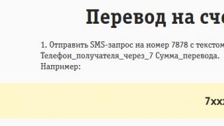
- You can easily download Navigator from Yandex at Play Market or AppStore. Click “Install” after you have found the application and wait a few seconds.
- Now log into the application. To find yourself on the map you need to enable geodata on your phone. Open the device tray by swiping your finger across the screen from top to bottom, click on the “Location Data” icon and wait until it changes color.

- Now your current location will be instantly determined.
- Pay attention to the most bottom panel in the program: all are located here necessary tools to work with the navigator. The most important thing is finding a route. Try to make your first path right now. Your location is automatically determined as point “A”. Find your destination on the map and click on that location.


- If you don’t know where the place you are looking for is, then just click on the “Search” icon. IN this menu you can either enter an address or place name, or search for it in categories.


- As soon as the system determines available list places, click on the desired one.


- Now you see possible options point “B” on the map.


- Click on one of them, and then select the “Let's go!” field.


- That's all. The path is automatically set. If you have several route options, the time and kilometers for each of them will be indicated at the top. The system will also notify you about traffic jams and repairs.


- Keep track of your path in the panel above. These tools will be very useful to you to quickly find your way on the road.


How to add favorite places to Yandex.Navigator
To get directions in just a couple of seconds, you can add your most frequently visited places to a special list.
- Open the “My Places” item.

- Here you will see convenient bookmarks, like “Home” and “Work”. Add addresses or points on the map to them.
- In the “Recent” section, you have access to all the addresses that you recently visited.


How to log in to Yandex.Navigator
Users authorized in the system can synchronize all settings on devices. This is very convenient if you have several phones or if you suddenly get lost with a friend who has such an application.
- Press “Menu” again and then the “Login” button.


- The convenience of the system is that you can use not only account Yandex for authorization, but also any social network.
- As soon as you log in and give the application access, authorization is complete.

How to set up Yandex.Navigator
The application has a user-friendly interface and many flexible settings. By selecting “Settings” in the menu, the following options become available to you:
- Map view from satellite or schematic.
- North location.

There are also minor points of interest:
- Announcer's voice. There's even Optimus Prime here.
- Setting up a call to Yandex using the “Listen, Yandex” command.
Customize the application to suit your needs and tastes.

Yandex.Navigator tools
There is a separate “Tools” item in the menu. You should know why it is needed.
Here you can mark your fines so that you always remember them, store your trip history, and quickly find nearby vehicle towing companies and commissioners. Don't forget to add fines so that the application reminds you of them.

How to add a mark on a map in Yandex.Navigator
If you have witnessed an accident or seen renovation work on the road, you can notify other drivers about it.
- Click on the location on the map where the traffic jam occurred. Select the triangle icon road sign left.


- Now note what exactly happened on the road and select a row if necessary. You can also simply leave a comment on this place by clicking on the gray icon.
- So simply you can communicate with other drivers right in your navigator.

While driving along the route, the following are visible on the Navigator screen:
Route segment
To view the entire route, click the button. To return to the current segment, press the button.
Route parameters:
- distance to destination and estimated time of arrival;
- traffic jams on the route;
- upcoming maneuver and distance to it;
- speed limit on the route section.
Note. If the speed limit shown by the Navigator is not correct, click the limit icon and select the current value.
Attention. If the setting is enabled North is always up, then traffic lanes are not shown.
Lanes are displayed in several major cities, at complex turns and intersections. Lanes are also shown if you need to stick to certain lanes when driving.
If the strip is intended for certain type transport, such as buses or bicycles, a special sign will appear next to it.
To ensure that the Navigator warns about cameras, speeding and traffic conditions, set up sound warnings about traffic events.
Work in the background
The navigator can work in background, that is, guide you along the route and give hints when the application is minimized. Background support works both with and without a constructed route.
IN modern world movement is an integral part Everyday life. The presence of cars and roads gradually speeds up the already fast pace. Implementation innovative technologies into the movement process made it possible to significantly simplify the implementation of movement.
Software systems that help the driver quickly figure out the route have gained great popularity. In our country, users give the greatest preference automated system"Yandex.Navigator", reviews of which eloquently reflect the opinions of users on this matter. And free distribution and unhindered installation on any available device only increase this effect.
"Yandex.Navigator": a brief overview
Yandex.Navigator is presented on all currently popular platforms - Android, iOS, Windows Phone. the main task this software product— calculation and planning of the optimal route for movement. The system is free.
In addition to its main tasks, the navigator shows the presence of traffic jams, accidents and simply road events along the route, the display of which, by the way, can be created by the users themselves, since the functionality allows this. The latest versions implement payment of fines through Yandex.Navigator. Reviews from numerous users vary, but from big picture you can understand that the application is really reliable and necessary. In addition, developers quickly respond to feedback from owners and correct errors that appear.
Application interface
The application interface is essentially a Yandex.Maps service optimized for route calculations. To make it easier to track your current location, in the settings you can switch to 3D mode, which tilts the camera slightly, slightly opening the view in the desired direction.

The map can display current events on the road, such as accidents, traffic jams or road works. You can enable their display using a special filter.
The voice control feature can be very convenient solution to use the navigator while driving. Although the ability to manually select a destination is also present. There are even two of them - in the form of a rubricator and text string with tips.

For current and stable operation cards require a constant Internet connection.
Instructions for use
Depending on the existing platform, before you start using Yandex.Navigator, you need to install it. It is available for free in the app stores of the corresponding brand - Android, iOS or Windows.
After the first launch of the application, you should wait for the definition exact location GPS-based or cell towers. The system will find the device and display it on the map as a green mark.

When you tap it, a panel with controls will appear at the bottom of the screen. Depending on the current state their purpose may be different. But before moving, they will have the following functionality:
- "Search". Takes you to the destination menu.
- "Map". This mode serves to go directly to the map from other menus.
- "My places." You can add frequently used routes to this item.
- "Menu". Contains basic program settings.
Application configuration
By going from the main screen using the “Menu” button to the settings mode, you can set required parameters to your liking. There are actually a lot of functions. Here you can determine how the map will look, select night or day mode, download complete sets kart.

Concerning sound notification, then here you can set the language and select the speaker’s voice. Current version allows you to set one of 4 options: Dima, Oksana, Utkin and Fyodor Bondarchuk, added in one of latest updates Yandex.Navigator application. Reviews, by the way, are full of user reports that their gadget now speaks in the voice of a famous director.
Additionally, you can configure what events you want to notify about, for example, speeding. Other settings include updates, events and synchronization.
You can also view available fines online from the menu and pay them immediately. To do this, just enter the number driver's license, registration certificate and your first and last name.
The “My trips” item allows you to view travel statistics. However, for this you will need to log in to the Yandex service.
If something bad happened on the road and the car was broken down, you can call a tow truck from the menu. Requests for assistance in starting the car, delivering fuel or changing a wheel are also available.
Building a route
To build a route to your destination, you need to wait until the device’s location is determined. Then touch the screen to display a pop-up menu. In it you need to select the “Search” button. If you have already traveled along this route using a navigator, it is saved in the “History” tab. If you need a new one, then you can create it in three ways.
In cases where the destination belongs to frequently visited places, such as cafes, restaurants, gas stations, cinemas and others, then simple method a rubricator will be used. By finding a category and clicking on it, you can see marks on the map of all places belonging to this type. When you select one of them, you will be asked to get directions using the “Here” button.
You can also enter the destination definition manually using the keyboard or by voice. After pronouncing the desired address the system will recognize and offer the most suitable option. The target is also selected from the list and the route is calculated.
Movement
After the strip along which you need to move is displayed on the map, just click on the “Let’s go” button to start moving. It is worth noting that Yandex.Navigator can offer several route options, the description of which will indicate the approximate travel time.
Once you find your destination on the map, it will appear with a blue mark. When you click on it it will appear context menu, through which the route calculation begins. If instead of the “Here” button you click on top part menu, a panel with information about this point, phone number, operating mode and other information will be displayed. You can also move here this item to the “My Places” category in order to visit it later, or call directly from the application by activating the item with the phone number line.

While driving, the navigator will periodically notify the driver about the need to turn in the desired direction using the selected voice. Moreover, the color of the route strip may be different depending on the traffic congestion. For example, green means that the path is clear, and red means there is a congestion or traffic is difficult. The map also displays speed cameras, which is very convenient.
"Yandex.Navigator": user reviews
The navigator has become a part of the lives of many drivers. For example, from Google Play app has been downloaded more than 10 million times. "Yandex.Navigator" for Android, the reviews of which are very diverse, occupies a leading position among other navigation programs in this store.
Users note that the application is accessible, but there are some shortcomings. Some people would like to see the fuel type displayed on the map along with gas station icons. Many complaints are directed at the fact that the navigator does not always build an accurate route or calculates it without taking into account detours and shortcuts.
Users were also amused by the voice of Fyodor Bondarchuk, added several updates ago to Yandex.Navigator for Android. User reviews immediately notified this. The director’s speech sounds exactly as everyone is accustomed to, with characteristic phrases and turns of phrase.
In general, we can conclude that users are satisfied with the application and are willing to install Yandex.Navigator on Android. Reviews are mostly positive. In addition, the development team responds to them very quickly.
Active people are interested in a variety of things navigation programs, allowing you to successfully create routes to any objects of interest. Yandex introduces a special mapping service called Yandex Maps. User-friendly interface, current information, high level functionality – the main advantages of the program. What can you expect when you carefully study the proposed application option?
Features of Yandex Navigator
Yandex Navigator – popular navigation app For Android devices, which can be downloaded from absolutely free without any problems. The volume of the distribution is about 12 megabytes.
The main task is to download Yandex Navigator. There is no need to download maps separately, because they are available on the Internet and can be cached on your smartphone. At the same time, there is no way to completely deflate the card.
Only latest versions Applications allow you to lay out various routes in off-line mode for a successful search for an object. If you are not satisfied with this application in some way, you can try installing one of the following.
Motorists can appreciate Yandex Navigator even more: the route line is colored in different colors, which depend on the intensity of traffic. Thus, even traffic jams cease to be dangerous, because in many situations they can be successfully avoided.
Features of working in Yandex Navigator
So, how to use Yandex navigator on Android? In fact, the application has the most simple usage scheme. The main task is to plot the route.

The driver must indicate the starting and ending points, and then familiarize himself with the travel options. The path may be the fastest or the shortest. At the top, information about the length and time of travel is published, which complements the routes.
Important requirement - correct setting displayed maps. The option is available to use 3D mode, night vision, automatic zoom or fixation according to the “north is always up” principle.
How to use Yandex Navigator in off-line mode?
To solve the problem, you need to go through four stages. However general process will require a minimum of time.
- You need to go to Yandex Navigator on your Android device.
- Go to Menu.
- Now you should download maps of the region.
- The download can be Review or Full.
Downloaded maps allow you to use Yandex Navigator in any conditions.