They allow you to obtain spatial information about the earth's surface in the visible and infrared ranges of electromagnetic wavelengths. They are able to recognize passive reflected radiation from the earth's surface in the visible and near-infrared ranges. In such systems, radiation hits the corresponding sensors, which generate electrical signals depending on the intensity of the radiation.
In optical-electronic remote sensing systems, as a rule, sensors with constant line-by-line scanning are used. You can select linear, transverse and longitudinal scanning.
The total scanning angle across the route is called the viewing angle, and the corresponding value on the Earth's surface is shooting bandwidth.
Part of the data stream received from a satellite is called a scene. The schemes for cutting the stream into scenes, as well as their size for different satellites, differ.
Optical-electronic remote sensing systems carry out surveys in the optical range of electromagnetic waves.
Panchromatic the images occupy almost the entire visible range of the electromagnetic spectrum (0.45-0.90 microns), and are therefore black and white.
Multispectral(multispectral) imaging systems produce multiple separate images over broad spectral regions ranging from visible to infrared electromagnetic radiation. The greatest practical interest at the moment is multispectral data from new generation spacecraft, including RapidEye (5 spectral zones) and WorldView-2 (8 zones).
The new generation of high- and ultra-high-resolution satellites, as a rule, survey in panchromatic and multispectral modes.
Hyperspectral imaging systems form images simultaneously for narrow spectral zones in all parts of the spectral range. For hyperspectral imaging, it is not the number of spectral zones (channels) that is important, but the width of the zone (the smaller the better) and the sequence of measurements. Thus, a shooting system with 20 channels will be hyperspectral if it covers the range of 0.50-070 microns, while the width of each spectral zone is no more than 0.01 microns, and a shooting system with 20 separate channels covering the visible region of the spectrum , near, short-wave, mid- and long-wave infrared regions will be considered multispectral.
Spatial resolution- a value characterizing the size of the smallest objects distinguishable in the image. Factors affecting spatial resolution are the parameters of the optical-electronic or radar system, as well as the orbital altitude, that is, the distance from the satellite to the object being imaged. The best spatial resolution is achieved when shooting at nadir; as you deviate from nadir, the resolution deteriorates. Satellite images can have low (more than 10 m), medium (from 10 to 2.5 m), high (from 2.5 to 1 m), and ultra-high (less than 1 m) resolution.
Radiometric resolution determined by the sensitivity of the sensor to changes in the intensity of electromagnetic radiation. It is determined by the number of gradations of color values corresponding to the transition from the brightness of absolutely “black” to absolutely “white”, and is expressed in the number of bits per pixel of the image. This means that in the case of a radiometric resolution of 6 bits/pixel, we have only 64 color gradations, 8 bits/pixel - 256 gradations, 11 bits/pixel - 2048 gradations.
An excellent program for viewing not only images of the Earth, but also the Moon and even Mars. It will become a faithful assistant to all virtual travelers.
Have you read Tolkien's book "The Hobbit or There and Back Again"? If “yes,” then you probably also wanted to travel with brave heroes somewhere to distant, unexplored lands. If “no”, then it doesn’t matter, it seems to me that you have had moments when you want to leave everything and go on your way.
Dreams are dreams, but everyday life does not always give us a break and allow us to take even a short walk outside the city. But I really want to see the world!
With the development of information technology, almost everything becomes real. Today you can, without leaving your home/office, explore, for example, all the sights of London and Paris. No, I'm not talking about web cameras that broadcast what is happening in different parts of the globe, but about a more global project - virtual satellite maps of the world.
Various world-famous services such as Google, Wiki, Yandex, etc. create their own variations on this theme, but the essence remains the same - to provide the user with the opportunity to see a satellite image of any area in high resolution.
If you are not yet familiar with any of these services, then I will tell you how you can very quickly correct this situation. Use the program SAS.Planet.
Features of SAS.Planet
- display of 33 maps from 16 different sources;
- work offline (maps are loaded from the cache);
- calculation of coordinates of a given area;
- calculation of distances between two or more points;
- work in tandem with a GPS navigator;
- loading and displaying wikimapia objects;
- creating maps of any area.
Today, SAS.Planet is one of the most, so to speak, comprehensive programs that can take us on a “tour” not only around the Earth, but also show us the closest part of the Universe!
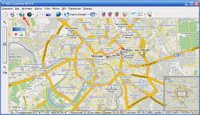
But there’s no need to rant too much, let’s get down to business. The program does not require installation, so all you have to do is unpack the downloaded archive into any folder (although the program also comes directly from the archive). Let's run the exe file of the program and see the following window:

Setting up SAS.Planet
The first thing to pay attention to is where you are configured to receive images from. By default you will have "Cache". This means that SAS.Planet works in offline mode, and information about maps comes from the program cache. To change this, click on the arrow next to the computer image and select one of two options: “Internet” or “Cache and Internet”.
If you choose the first option, then map files are displayed directly from the Internet, which increases rendering speed.
If you choose the second option, then all downloaded images are first cached (saved in the cache), and only then displayed on the map. This method takes longer, but in return you get all the viewed maps on your PC, and you can view and edit them at any time (having previously enabled working only with the cache).
Map display options
The maps themselves in the program come in several types (see the "Maps" menu): "Satellite", "Map", "Landscape".
"Sputnik" shows a direct satellite image of the selected area of the planet. This is perhaps the most interesting type of maps, since we can see even very small details (for example, see our house :)).
“Map” is an already processed satellite image, where all the detail comes down to highlighting transport routes (something like a world map of highways :)). This type of imagery can be used to create maps for GPS devices.
“Landscape” is also a simplified version of a satellite image, but at the same time with detail on relief forms. These maps can also be used in GPS navigators if you plan to travel on foot.
Additional layers on maps
In addition to these types of maps, SAS.Planet also has a “Layers” menu. Here you can find unique “overlays” on the main maps that expand their functionality or information content. Let's look at some of them.
If you live in a big city where traffic jams constantly occur on the roads, you can easily avoid this trouble thanks to the “Traffic” layer.

The map displays in several colors those roads that are free (green), relatively free (yellow) and “clogged” (red). All you have to do is study the free routes and plan your path so as to avoid all traffic jams.
Wikimapia landmarks layer
For curious people who are interested in various interesting places in different cities, there is a "Wikimapia" layer.

By activating this layer, you will see highlighted areas on the map that correspond to the location of points of interest. All you need to do is click on this area, and a description will appear in front of you with a photo (or without) of this place.
Panoramio Photo Layer
And, continuing the theme of virtual travel, let's pay attention to the "Panoramio" layer.

This service allows you to post and view photographs of different areas. After activating the layer, small circles will appear on the main map, which indicate photographs taken in one place or another.
Maps of space objects
Oh yes! I completely forgot about space maps. Maps of the Moon, Mars and the Starry Sky are available in SAS.Planet.

Just select the one you need in the “Maps” menu (section “Space”), and at least for a minute become an “astronaut” :). The only negative is that these maps do not have layers that contain information about your current location. Although, as they say, every cloud has a silver lining.
I suggest a little “game” :). Turn on a regular map of the Earth, find your city and, without changing the position of the map, replace it with a map of the starry sky or Mars, say. Believe me, it’s quite an interesting activity :).
But this is all, as they say, lyrics. Let's continue to get acquainted with the program. And now let's look at its additional functions.
Editing a map
And the first of them is selecting and editing the map. Activate, for example, the “Rectangular Area” tool and select part of the depicted map (for example, the center of Moscow). The following window will appear:

The most interesting functions here are “Glue”, “Shape” and “Export”. Using all these tools, you can create your own map, independent of the program, and save it.
“Glue” allows you to create your own map from several separate tiles (parts of a map in SAS.Planet). All you need to indicate is the number of fragments, the quality of the final image and create GPS bindings (you don’t have to create them).
The "Generate" tool allows you to create a map of the same area, but with a lower resolution, from an already loaded map with a certain resolution. Unclear? Let me explain: let’s say you have a map of the same Moscow with a magnification of 12. From it you can recreate all the maps of a smaller scale (11, 10, 9...). All you need to do is indicate the final scale.
Thanks to "Export" you can directly, without unnecessary hassle, convert the finished map into the desired format (for example, for iPhone).
Measuring distances between points
Having SAS.Planet at hand, you can easily find out the distance from point “A” to point “B”. Activate the "Measure Distance" tool and draw your path. For example, we want to find out how far it takes to walk from the Kitay-Gorod metro station to the Chkalovskaya metro station. We draw a “path” and at the very end we see the result accurate to centimeters.
If you are the happy owner of a GPS navigator, then you can easily synchronize SAS.Planet with it. All you have to do is click on the “Connect to GPS receiver” button and its location will be displayed on your map.
conclusions
Now you know almost everything about the SAS.Planet program. When planning your trip, do not forget to stock up on maps of the place where you are going and you will never get lost in unfamiliar terrain. Moreover, the cards can be saved as ordinary drawings (for example, take a screenshot of the screen) and download them to your mobile phone or print them on a printer (whichever you prefer :)).
P.S. Permission is granted to freely copy and quote this article, provided that an open active link to the source is indicated and the authorship of Ruslan Tertyshny is preserved.
Programs and services | | 24.09.2014 | Yuri Nasonov
Often, as a background, you want to use satellite images or maps from the Google Maps/Yandex maps/OpenStreetMap service... At the same time, one screenshot is not enough here - the quality will not be the same and you will have to glue several images together.
To automatically download cards from popular services, the SAS.Planet program was created. You can choose any service, any quality and any area, even the entire city. The program is free and available in Russian.
Available maps are Google Earth, Google Maps, Bing Maps, DigitalGlobe, Kosmosnimki, Yandex.maps, Yahoo! Maps, VirtualEarth, Gurtam, OpenStreetMap, eAtlas, iPhone maps, General Staff maps, etc. Moreover, you can choose both satellite images and graphic maps.
So, in order
1. Installation of the program
- Download the program from .
- Unpack the archive - no installation required
2. Setting up the program

3.Selecting the desired area
- Select the desired graphic or satellite map. If Sputnik (Google) does not work, try Sputnik (Yandex).

- If necessary, we connect additional layers, for example, plugs.

- Having found the desired place on the map, select the area that we want to download

4.Downloading the map
- In the window that opens, make sure the settings are correct and click Start. When finished, click “Exit”. The scale of the map can be seen at the top left. The larger the scale, the longer the image will take to load and stitch together.


5. Saving the map
- Now we need to glue and save the loaded tiles. To do this, select “Previous selection”

- On the Merge tab, specify the format, save path and the scale at which you downloaded the tiles, begin…

Many users are interested in online satellite maps, which give them the opportunity to enjoy a bird's-eye view of their favorite places on our planet. There are quite a number of such services on the Internet, but all their diversity should not be misleading - most of these sites use the classic API from Google Maps. However, there are also a number of resources that use their own tools to create high-quality satellite maps. In this material I will talk about the best high-resolution satellite maps available online in 2017-2018, and also explain how to use them.
When creating satellite maps of the earth's surface, both images from space satellites and photos from special aircraft are usually used, allowing photography to be carried out at a bird's eye view (250-500 meters).
Satellite maps of the highest resolution quality created in this way are regularly updated, and usually the images from them are no more than 2-3 years old.
Most online services do not have the ability to create their own satellite maps. They usually use maps from other, more powerful services (usually Google Maps). At the same time, at the bottom (or top) of the screen you can find a mention of the copyright of a company for displaying these maps.

Viewing real-time satellite maps is currently not available to the average user, since such tools are used primarily for military purposes. Users have access to maps, photographs for which were taken over the past months (or even years). It is worth understanding that any military objects may be deliberately retouched in order to hide them from interested parties.
Let's move on to a description of the services that allow us to enjoy the capabilities of satellite maps.
Google Maps - view from space in high resolution
Bing Maps – online satellite map service
Among online mapping services of decent quality, one cannot ignore the Bing Maps service, which is the brainchild of Microsoft. Like other resources I have described, this site provides fairly high-quality photos of the surface created using satellite and aerial photography.
 Bing Maps is one of the most popular mapping services in the United States.
 The functionality of the service is similar to the analogues already described above:
At the same time, using the search button you can determine the online location of a specific satellite, and by clicking on any satellite on the map you will receive brief information about it (country, size, launch date, etc.).

Conclusion
To display high-resolution satellite maps online, you should use one of the network solutions I listed. The Google Maps service is the most popular worldwide, so I recommend using this resource to work with satellite maps online. If you are interested in viewing geolocations on the territory of the Russian Federation, then it is better to use the Yandex.Maps toolkit. The frequency of their updates on our country’s relations exceeds the similar frequency from Google Maps.